Roosevelt Island
FEATURE
SEASON 2 · EPISODE 4 · SEPTEMBER 2026
Photography and story by John Menzies
Roosevelt Island is a narrow strip of land in the East River between Manhattan and Queens. It runs about two miles long and is never more than 800 feet wide.
One way to get there is the Roosevelt Island Tramway — a red aerial gondola, the kind of thing you would expect to find running up the side of a mountain. This one runs over the East River, 250 feet up, four minutes from Manhattan to the island.
Step off the tram and there is a lot to look at. Giant red letters — RI — against a large Manhattan skyline. The Queensboro Bridge directly overhead. The East River moving fast on both sides, boat traffic cutting through it.
The giant RI letters greet visitors beside the tram station, with the Queensboro Bridge passing overhead.
None of it looks like what this island used to be.
Blackwell's Island
The Lenape — the New York region’s indigenous people — called it Minnahanonck sometimes translated as “nice island”. The Dutch pastured pigs on it and called it Hog Island. Then it belonged to the Blackwell family, and for more than two centuries it was Blackwell's Island.
In 1828, the City of New York bought it.
They were going to turn the island into the city's institutional center.
The penitentiary came first. Then the lunatic asylum. In 1856, the city added a smallpox hospital. Much of the gray stone used to build the island’s institutions came from the island’s own quarry and was quarried by prisoners from the penitentiary.
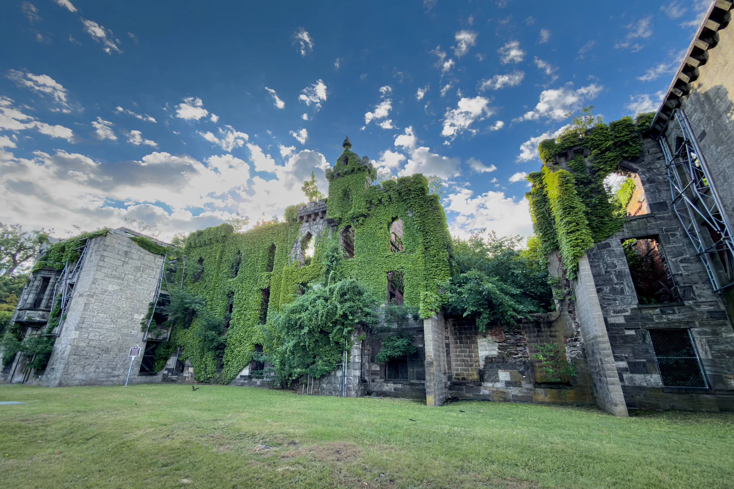
The former Smallpox Hospital survives at the island’s southern end as a roofless stone ruin. It is the only ruin in New York City designated as an official city landmark.
The people confined on the island could see Manhattan across the river. Reaching it was another matter. Back then, the only way across was by boat, and service was limited. The East River’s strong currents made the crossing difficult. Only the city’s own boats were permitted to dock. Visitors needed a permit from the department that ran the institutions.
For all those restrictions, stories still made their way off the island. Some were about the asylum. Mistreatment. Neglect. Patients abused by the people paid to care for them. The New York World newspaper wanted to know whether the stories were true.
So the paper sent someone in.
In September 1887, the World's managing editor asked a twenty-three-year-old reporter named Nellie Bly whether she could get herself committed. She took a room at a boarding house for working women and spent one night unsettling the other residents. They called the police. A judge sent her to be examined. The doctors agreed she was insane.
That was all it took.
The ferry took her across. She stayed ten days.
She stopped acting the moment she arrived. She spoke normally, answered questions plainly, told the doctors she was not insane. The more normally she behaved, the more convinced they became that she was insane.
Some of the women she found there couldn’t speak English. Their inability to answer questions in English had helped put them there. Others were there for being poor and having no family to object.
On the tenth day the World's lawyer came for her and she went home.
At Roosevelt Island’s north tip, Amanda Matthews’s The Girl Puzzle stands beside the 1872 lighthouse, built from island gneiss. The memorial honors Nellie Bly and women and girls she wrote about and advocated for.
The paper published her account that October. A grand jury opened an investigation. The city fired the abusive staff. It changed the examination procedures so that only the seriously ill were committed. It hired multilingual staff to work with the immigrant patients. It put $50,000 into the asylum — roughly $2 million today.
The asylum got better.
The island did not.
Welfare Island
The Queensboro Bridge opened in 1909. During construction it was called the Blackwell's Island Bridge, until property owners in Manhattan and Queens petitioned to have the name changed — they did not want their bridge named after an island of prisons and asylums. So it opened as the Queensboro, crossed directly over the island, and offered no way down.
From Roosevelt Island, the Queensboro Bridge still passes directly overhead on its way between Manhattan and Queens.
Ten years later the city solved that by constructing a ten-story building on the island which was connected to the bridge by a roadway at its top floor. It was the only way to drive on or off. It frequently broke down.
In 1921, the city renamed the island Welfare Island, hoping a new name would fix its reputation. But a new name couldn't fix the penitentiary. In 1934, the city's new Correction Commissioner made a surprise inspection and found the place effectively being run by its own inmates. Two inmates in particular enjoyed extraordinary privileges and had homing pigeons that would carry narcotics in and messages out. One of them had a private garden inside the prison. Flowers, benches, and a goat he kept for the milk.
The warden was fired and the prisoners were moved to a new penitentiary on Rikers Island.
Two decades later, the island looked quite different. A small bridge to Queens opened in 1955, giving drivers a much simpler way on and off.
The penitentiary was gone. The asylum had closed decades earlier. By the 1950s, even the former smallpox hospital building had been abandoned. By the late 1960s, much of the island lay unused. Two miles of open ground in the middle of New York City. Water on both sides. Manhattan close enough to see.
Mayor John Lindsay appointed a committee and asked what to do with it.
Roosevelt Island
The city decided to build a town on it.
The architects Philip Johnson and John Burgee drew up the master plan in 1969, and what they proposed reads like a wish list. Twenty thousand people. Mixed income, by design. Housing for low-, middle-, and higher-income residents on the same small island. One Main Street, built around walking. A promenade running the full shoreline. Every apartment with a view of the water.
The waterfront promenade remains one of the clearest pieces of the 1969 plan still visible on Roosevelt Island.
And no private cars beyond the bridge. Drivers would cross from Queens and leave their cars at Motorgate, a garage built at the bridge. From there, residents would walk or ride buses through the island.
Also no garbage trucks. Not fewer — none. Residents would drop their trash down a chute in their building, and it would be pulled through 20-inch pipes under the island to a collection point at the north end. Very few places in America had built anything like it. Walt Disney World installed the same system under the Magic Kingdom in 1971. Roosevelt Island's went in four years later.
At the north end of Roosevelt Island, the pneumatic waste system empties into this collection facility.
One of the large red pipes inside the facility is part of the system that carries trash through the island.
In 1973, with construction underway, the island was renamed one last time, for Franklin D. Roosevelt. Two years later the state's development corporation defaulted. Fewer than half the planned apartments had been built and further development stalled.
The first residents moved in anyway.
Getting them to and from Manhattan was the harder problem. The promised subway was years from opening, and the old bridge elevator was gone.
An architect named William Chafee proposed a cable car and the Roosevelt Island Tramway opened in May 1976. It was the first commuter aerial tram in North America, but it was only meant to last until the subway to the island was finished.
The subway took thirteen more years, and by the time it opened in 1989 the tram had been carrying the island for over a decade.
It never stopped.
The tram terminal sits where the old elevator building once connected Roosevelt Island to the Queensboro Bridge overhead.
What’s Still Here
About twelve thousand people live on Roosevelt Island now. Free Red Buses run from one end to the other. People eat lunch along Main Street. Flocks of geese graze on the broad lawns nearby.
Roosevelt Island’s free Red Bus runs the length of the island, part of a transportation system still shaped by the compact, pedestrian-first plan.
Flocks of Canada geese are a familiar presence on Roosevelt Island’s broad lawns.
The pneumatic system still runs, fed by trash chutes inside the apartment buildings. Motorgate is still there, but the car-free plan did not survive completely. Private cars now use the island's streets. In the couple of days I spent there, I walked the island end to end more than once and saw relatively few of them moving. Most people I passed were walking, jogging, or riding the free Red Bus.
One part of the asylum still stands. Its octagonal entrance and administration building is now the lobby of a luxury apartment complex.
The surviving entrance and administration building of the former asylum is now part of a luxury apartment complex at 888 Main Street — appropriately called The Octagon.
Same octagonal stone building. Different doorman.
In 2017, Cornell Tech opened a graduate engineering campus on the island’s southern end. The Bloomberg Center was designed for net-zero energy use, while the Tata Innovation Center houses university researchers and technology companies together under one roof — adding a very different chapter to the island’s long institutional history.
Cornell Tech’s pedestrian campus stretches south from the bridge toward the island’s tip.
Two Roosevelts
Walk south past the campus and the island narrows.
The first thing you come to is a memorial to Franklin D. Roosevelt. Disabled residents of this island spent more than a decade working to put it there.
The Roosevelt memorial stands near the island’s southern end, between Cornell Tech and Four Freedoms Park.
Keep walking and the island ends at Franklin D. Roosevelt Four Freedoms Park, designed by Louis Kahn. A lawn narrows between two rows of linden trees. At the end of it, a second Roosevelt. This time, a bronze portrait — the confident public image he spent twelve years presenting to the world.
Louis Kahn’s Four Freedoms Park narrows toward Roosevelt’s bronze portrait at the southern end of the island, with the city continuing beyond the river.
He contracted polio at thirty-nine and never stood unaided again. He used a wheelchair for the rest of his life — through his presidency. The press largely agreed not to photograph him in it.
Twelve years in office. A handful of photographs.
Everywhere in the World
The Four Freedoms Park is named for a speech that Roosevelt gave to Congress in January 1941, eleven months before Pearl Harbor. He said there were four freedoms that belonged to everyone, everywhere in the world.
Behind it is a room of granite blocks, open to the sky, at the last point of land on the island. The words are cut into the wall.
Louis Kahn conceived the memorial as “a room and a garden.” The linden-lined lawn forms the garden; this roofless granite enclosure at the island’s tip is the Room.
Freedom of speech. Freedom of worship. Freedom from want. Freedom from fear.
Cut into granite, at the end of an island New York used for more than a century to isolate prisoners, patients, the sick and the poor from the rest of the city.
That complicated history is still here, in plain sight. So is the remarkable place that grew around it.
And that is the story behind the place.
Author’s Note: With thanks to my friend Adam Guy of I Know A Guy NYC Tours, who introduced me to Roosevelt Island and inspired me to look more closely at its story.
THE STORY CONTINUES
Get the next Story Behind The Place delivered to your inbox each month.
KEEP EXPLORING THIS PLACE
See the complete photography collection, including photographs that didn't appear in the story and selected images available as prints.